


The Fortunate Islands
Part I: An Interplay of Geography and Climate.

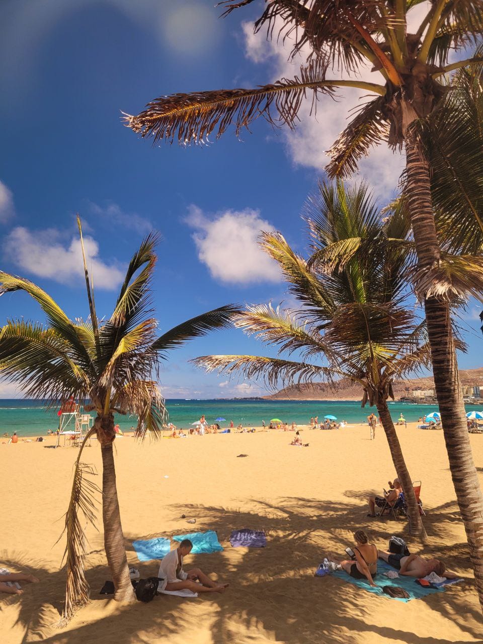
I recently returned from a fascinating trip to the Canary Islands, and I'm eager to share some of my experiences and reflections.
Prepare yourself for a visual journey – this post is packed with maps and diagrams designed to make complex concepts easily digestible.
But it doesn't stop there! Get ready for part two, coming soon, where we'll explore how geography and history have intertwined to shape the Canary Islands' unique story.
Location
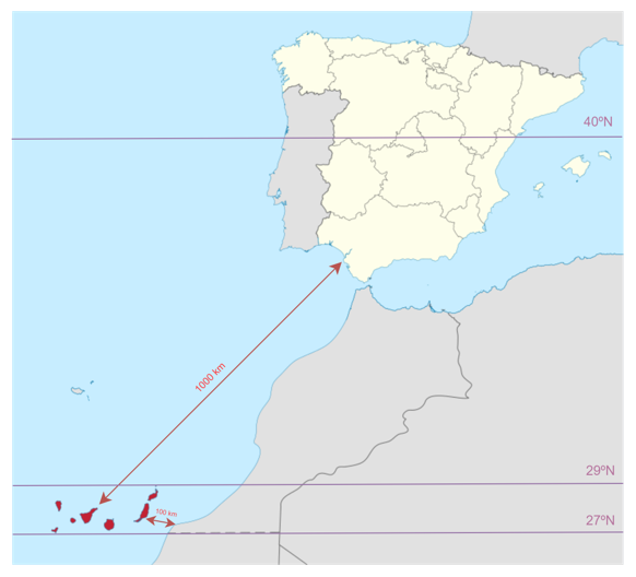
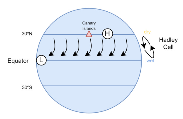
First, consider the islands' position on the globe. Their latitude, roughly between 27° and 29° North, places them within the subtropical zone. This means they lie within the belt of descending air, a key element of the Hadley Cell circulation pattern, named after 17th century meteorologist George Hadley. Descending air, known for its dryness, is a significant factor in creating the islands' warm, arid climate.
Millions of years ago, eruptions on the ocean floor, fueled by the Earth's internal heat, gradually built up volcanic cones that eventually emerged from the waves, creating this archipelago we know today.
What is this conveyor belt you are talking about?
Let's try to understand it intuitively. Imagine the Earth as a giant, unevenly heated oven. The equator, bathed in the most direct sunlight, acts as the hottest zone. While the poles, receiving slanted rays, represent the cooler areas. This temperature disparity sets the stage for our Hadley engine.
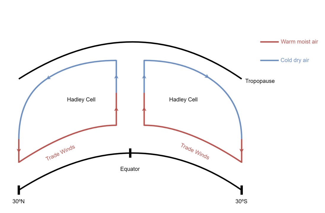
Let’s situate ourselves in the equator. Imagine you are a drop of water floating. Like a hot air balloon, the intensely heated air becomes less dense and rises. This creates a zone of low pressure at the surface. As the air ascends, it enters cooler regions of the atmosphere. Guess what happens next – it cools down. The cooling causes the moisture in the air to condense, forming clouds and heavy rainfall typical of equatorial regions. This is why you see rainforest around equator! The now-cooled, dry air aloft is pushed towards the poles by the continuous updraft from below. Imagine this as a conveyor belt in the sky, transporting air masses away from the equator. Around 30 degrees latitude (go check again the location of the Canaries), both north and south of the equator, the cooled air becomes dense enough to descend.1 This downward flow creates zones of high pressure, often associated with clear skies and dry conditions—think of the Sahara Desert, a prime example. As the descending air hits the surface, it splits. Some flows back towards the equator, completing the loop of the Hadley Cell. This surface-level flow, characterized by warm, dry winds, is what we call the Trade Winds. But some other continue to the north.
But what forces the air to come back to the Equator?
We hinted before that when the air descends it splits. But why doesn't it simply keep traveling in that direction? This is where the Coriolis effect takes center stage, guiding the air back towards the equator.
While it might seem intuitive that air simply flows "straight back" to the equator after rising and being deflected poleward, the Coriolis effect plays a crucial role in guiding this return journey. As the air at high altitudes moves away from the equator, it carries its eastward momentum. However, remember that the Earth's rotational speed decreases as you move towards the poles. This means that the air, still moving eastward at a relatively faster pace, starts to outpace the Earth's rotation underneath it. This difference in speed causes the air to curve back towards the equator. Therefore, it's not just a simple pressure gradient pulling the air back; the Coriolis effect, acting in concert with the Earth's rotation, provides a crucial "steering" force, shaping the air's path back towards the tropics.
But what about the Ocean?
Well … its influence on the Canary Islands' climate is just as profound as the atmospheric forces we've discussed. The islands' position amidst the Atlantic Ocean plays a crucial role, particularly their interaction with the Canary Current.
The Canary Current is a northward-flowing ocean current originating from the North Atlantic, carrying cooler waters from higher latitudes towards the islands2. As this cool current encounters the warmer air of the subtropics, it acts as a moderating force. This interaction has two primary effects: tempering coastal temperatures and increasing humidity along the western coasts of the islands.
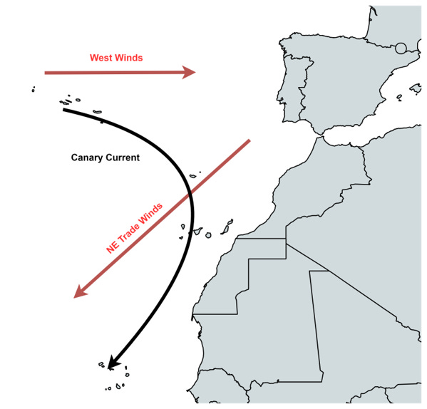
This injection of moisture is particularly significant. The Canary Current essentially acts as a buffer against the arid conditions prevalent in the region. It creates a distinct contrast between the western and eastern islands. While the easternmost islands, situated further from the current's influence, often exhibit landscapes akin to the Sahara Desert, the western islands enjoy relatively milder temperatures and increased humidity.
A Sea of Clouds
The Canary Islands' climate is shaped by a captivating atmospheric dance between the descending air of the Hadley Cell and the cool embrace of the Canary Current. This interplay gives rise to a fascinating phenomenon known as the trade wind inversion.
Picture this: dry air, descending from the upper reaches of the Hadley Cell, collides with the cool, moist air lingering above the Canary Current. This encounter creates a stark temperature discontinuity, a kind of atmospheric layer cake. Unlike the typical scenario where temperatures decrease with altitude, here, the opposite occurs. Atop the cooler, near-surface air, a layer of warmer air settles in, forming what we call a temperature inversion.
Here's a simplified equation to illustrate the concept:
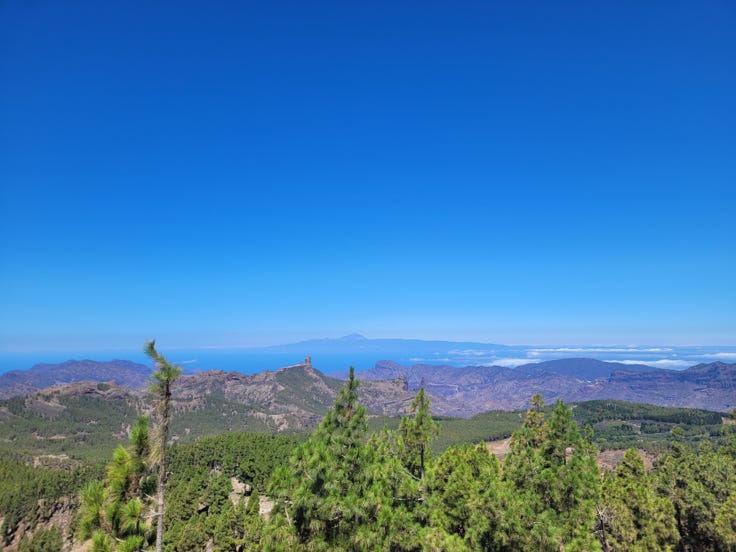
This inversion manifests as a visible boundary, often forming a breathtaking “sea of clouds” (Mar de Nubes) visible from the highest peaks. Interestingly, the altitude of this cloud ceiling isn't fixed. It fluctuates with the seasons, rising higher during the summer months when the Hadley Cell strengthens and pushing further poleward, and descending to a lower altitude in winter as the Hadley Cell weakens. This seasonal shift influences not only the types of clouds that form but also where rain falls across the islands. The inversion itself forms because the moist, surface air, influenced by the Canary Current, cools faster than the drier air descending within the Hadley Cell. This distinct separation acts like a lid, limiting the vertical growth of clouds and influencing rainfall patterns across the islands.
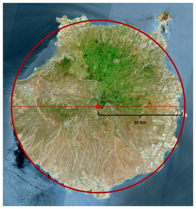
Gran Canaria's Topographic Surprise
Now, let’s zoom in on Gran Canaria, one of the most fascinating of the Canary Islands, its unique topography comes into sharp focus. Imagine a near-perfect circle, its diameter spanning approximately 40 kilometers. At the heart of this circle, rising to a majestic 1,950 meters, stands Pico de las Nieves, the "Peak of the Snows," a sentinel surveying its domain.
This striking central peak acts as the maestro of Gran Canaria's microclimates, orchestrating the distribution of rainfall and shaping the tapestry of vegetation across the island. Its influence is most dramatically evident in the rain shadow effect.
As moisture-laden trade winds, encounter the slopes of Pico de las Nieves, they are forced to ascend. This ascent causes the air to cool, its capacity to hold moisture diminishes, and the inevitable occurs: precipitation. The northern slopes of Gran Canaria, generously showered by this orographic rainfall, burst forth with lush vegetation (check the image above if you don’t believe me).
The southern flank of the island, shielded from the rain-bearing winds by the central highlands, experiences a different reality. Starved of moisture, this region falls under the rain shadow cast by Pico de las Nieves. Significantly lower rainfall and arid landscapes dominate, even giving rise to the remarkable dune fields of Maspalomas.
As you ascend in the island you will realize the stark change in vegetation. However we will see that phenomena in a follow-up post.
The Dance of Wind and Water
Having explored the location and dramatic topography of the Canary Islands, we lift our gaze skyward, where an intricate ballet of wind and water unfolds. High above the volcanic peaks and verdant valleys, the invisible hand of the Hadley Cell guides a perpetual dance, orchestrating the unique climate of these enchanting islands.
Gran Canaria, bathed in sunshine, sits beneath the descending arm of this global circulation pattern. Imagine warm air, stripped of its tropical moisture, making its descent from great heights, like a delicate veil settling upon the island. This is the source of the stable, sun-kissed days that grace the Canaries for much of the year.
But the dance doesn't end there. The descending air, upon reaching the surface, awakens the trade winds, setting them in motion. These persistent winds, flowing back towards the equator, carry with them the breath of the ocean, a whisper of moisture that becomes a roar as it encounters Gran Canaria's dramatic topography.
Here, the island itself takes center stage, its towering peaks guiding the moisture-laden air upwards. Forced to ascend, the air cools, its capacity to hold moisture dwindles, and a symphony of rain and mist erupts over the northern slopes, painting them in hues of emerald green. Meanwhile, the southern valleys, shielded from this watery embrace, slumber in the warmth of the rain shadow, their landscapes painted in shades of ochre and gold.
And so, the dance continues, a delicate balance between global forces and local landscapes, shaping a climate as diverse as the islands themselves. The Canary Islands, a testament to the artistry of nature, where wind and water waltz in a timeless embrace, shaping a world of captivating contrasts.
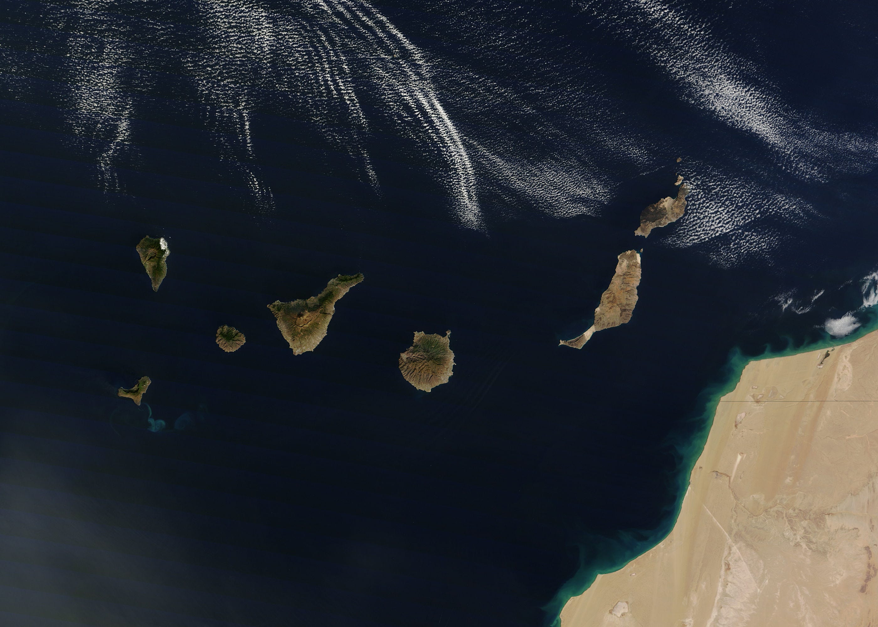
Trivia Question
In the next image what can you say about the colors you observe in the islands? Is there a pattern going from Nort to South, or maybe East-West?
This process, known as convection, is a fundamental driver of weather patterns.
In fact, it belongs to a biger oceanic conveyor belt: the North Atlantic Gyre.